MAPS
|
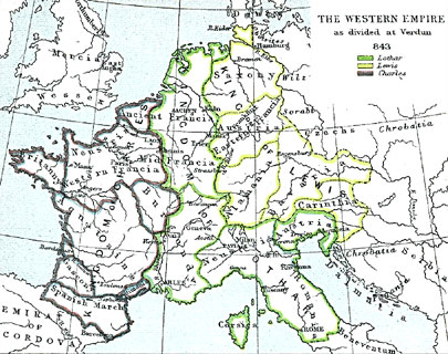
Map
of the Western Empire as divided at Verdun in 843
|
 |
|
On this map, the area outlined in green is controlled by Lothar, the area in yellow is controlled by Lewis, and the portion in purple is controlled by Charles. Click here to see a much larger copy of this map (1013 pixels; 316 K). |
|
The map is from the Atlas to Freeman's Historical Geography, edited by J.B. Bury, Longmans Green and Co. Third Edition 1903. It is in the public domain and was downloaded at http://historymedren.about.com/library/atlas/blatmapwestemp843.htm |
|
the
Rhone River
|
This page was updated on 8 April, 2004 by K. Epps
Unless
otherwise mentioned, all photos are by Katharine Epps.
Sauf mention contraire les photos sont de Katharine Epps
nyon@isg-online.org